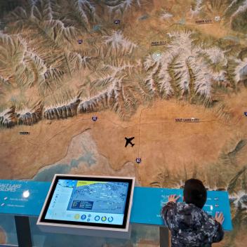
One of our most popular exhibits is the large topographical map of the Wasatch mountains, across from the Photo Booth. Using buttons to illuminate Greater Salt Lake ski area locations, visitors get a bird's eye view of the mountain range in which Utah's ski industry was spawned. Alta, Brighton, Deer Valley, Nordic Valley, Park City Mountain, Powder Mountain, Salt Lake City Airport, Snowbasin, Snowbird, Soldier Hollow, Solitude, Sundance, Utah Olympic Park, and Woodward are all displayed.
Additionally, interactive touch screens provide history, geography, and trivia for each of the ski resorts featured on the map. The monitor highlights the beauty of our Wasatch Mountain winter playground with a slideshow of stunning scenic images. Come check out our Resort Profiles and learn more about your favorites.
